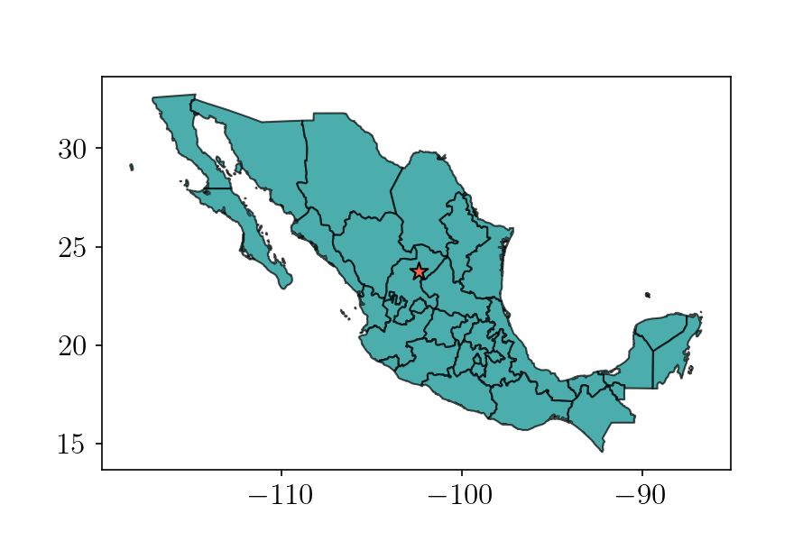
San Luis is the center, right?
How I spent a Sunday afternoon proving this…
So… where are you from?
Introductions can be complicated. First is the name:
“My name is Francisco, but you can call me Paco…”
I usually bridge across phonetic confusion by adding:
“… it’s like Taco, but with a P”.
Most people get it then as the popular food reference sinks in. Skipping over the details on how “Francisco” shortens to “Paco” comes the question about the origin:
“I am originally from Mexico…”
Ever since we moved to Southern California this is not enough information. Province-level precision is often on demand so I expand:
“I am from San Luis Potosi…”
Wait five seconds or so, then add:
“…it’s a city in the center of Mexico, a five hour drive north of the capital”
Still, the confusion often remains; wasn’t Mexico City supposed to be the center of the country? Perhaps it is in some aspects, but surely not geographically.
This exchange is not exclusive of international folks, my fellow mexicans will often question my affirmation about the geographical description of my place of origin. More specifically, people from the capital often consider San Luis Potosi is a nothern city. Perhaps it is in some aspects, but surely not geographically.
Amateur geographer
I decided to educate myself on the geographical attributes of my state of origin. A quick search on the web taught me Mexican territory over spans a little over 18 degrees of latitude from its southernmost corner at approximately 14 degrees, to the northernmost point at over 32 degrees north of the equator. By a simple estimate, the purely geographical north/south division must lie along the 23 degree latitude. According to wikipedia sources, the state of San Luis Potosi is centered at just over 22 degrees latitude. This was enough to make me edit the formerly wrong wikipedia entry for San Luis Potosi which described the state as a center-north region. Perhaps it is in some aspects, but surely not geographically.
This didn’t quite convince some of my most fervent chilango skeptics. I needed more evidence so I played with geopandas, a geographical dataframe package for python. Following the convention of a couple of geographical data analysis repositories around github, I pulled the latest dataset I could find with a high resolution polygonal representation of the mexican territory. The dataset comes from the CONABIO, a government agency dedicated to the concentration of information resources for mexican biodiversity. I coded up a calculation of the mexican territory centroid including insular land (islands), and put the results in a public repository.

The centroid’s latitude, even after correcting for the area preserving projection (thanks to bilbo!), is over 23 degrees. This not only settles the apparent question of geographical location of San Luis, but also gives me infinite confidence for my next unsuspecting introduction.
Thanks for reading! Paco